Conceptual Master planning for Letchworth Grange North Residential Development
Relating the site context:
Client: Letchworth Garden City Heritage Foundation
Location: Grange North, Letchworth
Design: competition
Design Stage: conceptual masterplanning
Design team: Jing Wu, Danyal Raza, Jason Norris, Ovidija Zemaityte
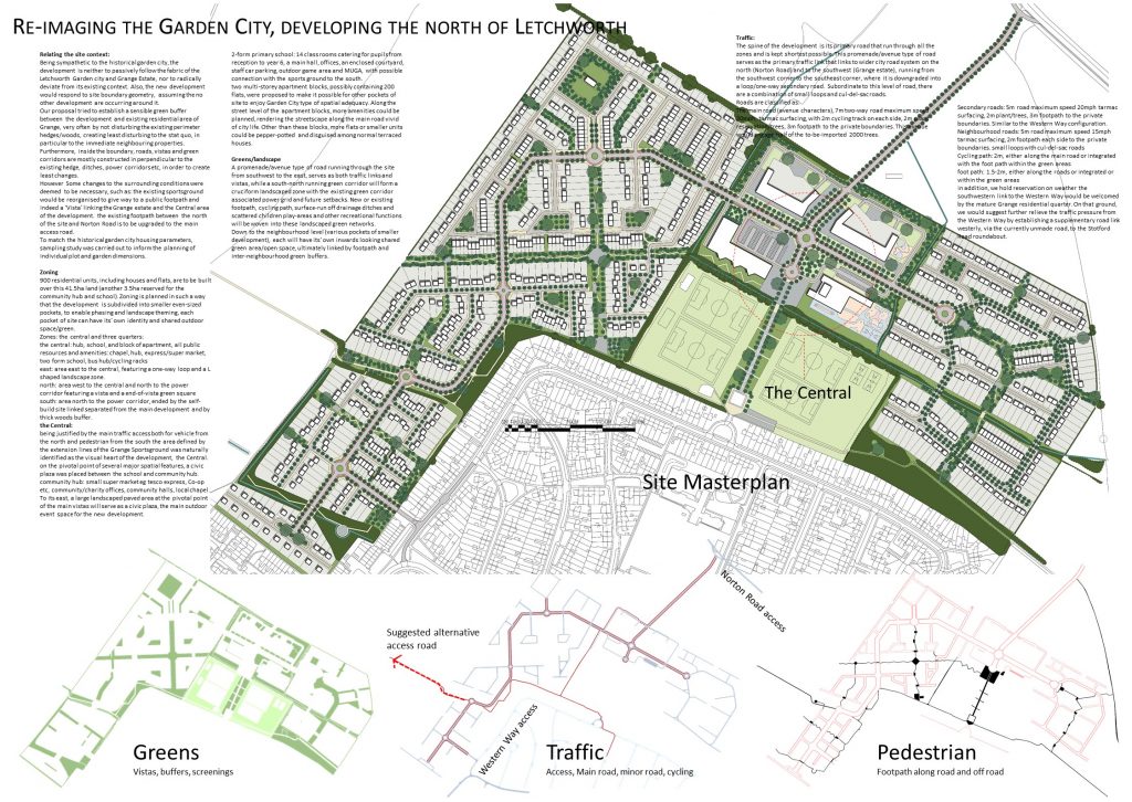
Being sympathetic to the historical garden city, the development is neither to passively follow the fabric of the Letchworth Garden city and Grange Estate, nor to radically deviate from its existing context. Also, the new development would respond to site boundary geometry, assuming the no other development are occurring around it.
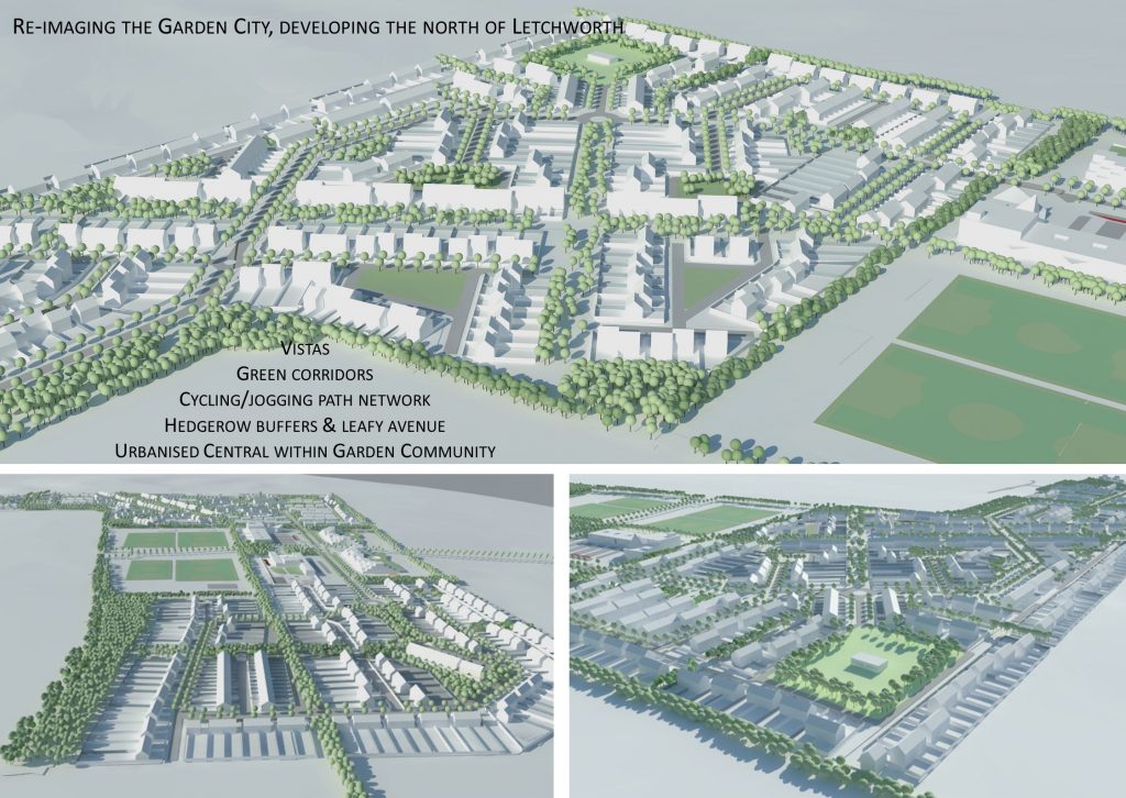
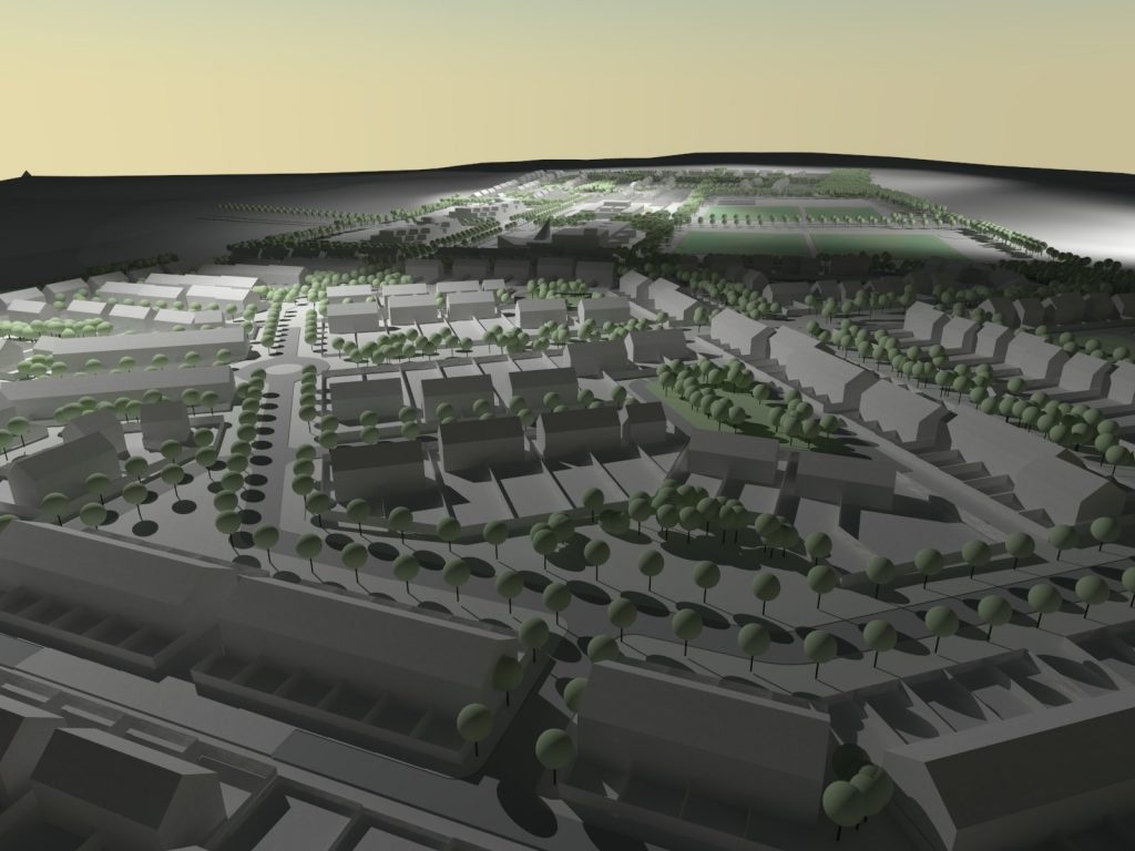
Our proposal tried to establish a sensible green buffer between the development and existing residential area of Grange, very often by not disturbing the existing perimeter hedges/woods, creating least disturbing to the stat quo, in particular to the immediate neighbouring properties. Furthermore, inside the boundary, roads, vistas and green corridors are mostly constructed in perpendicular to the existing hedge, ditches, power corridors etc, in order to create least changes.
However Some changes to the surrounding conditions were deemed to be necessary, such as: the existing sportsground would be reorganised to give way to a public footpath and indeed a ‘Vista’ linking the Grange estate and the Central area of the development. the existing footpath between the north of the site and Norton Road is to be upgraded to the main access road.
To match the historical garden city housing parameters, sampling study was carried out to inform the planning of individual plot and garden dimensions.
Zoning
900 residential units, including houses and flats, are to be built over this 41.5ha land (another 3.5ha reserved for the community hub and school). Zoning is planned in such a way that the development is subdivided into smaller even-sized pockets, to enable phasing and landscape theming, each pocket of site can have its’ own identity and shared outdoor space/green.
Zones: the central and three quarters:
- the central: hub, school, and block of apartment, all public resources and amenities: chapel, hub, express/super market, two form school, bus hub/cycling racks
- east: area east to the central, featuring a one-way loop and a L shaped landscape zone.
- north: area west to the central and north to the power corridor featuring a vista and a end-of-vista green square
- south: area north to the power corridor, ended by the self-build site linked separated from the main development and by thick woods buffer.
the Central:
being justified by the main traffic access both for vehicle from the north and pedestrian from the south the area defined by the extension lines of the Grange Sportsground was naturally identified as the visual heart of the development, the Central.
on the pivotal point of several major spatial features, a civic plaza was placed between the school and community hub.
- community hub: small super market eg tesco express, Co-op etc, community/charity offices, community halls, local chapel. To its east, a large landscaped paved area at the pivotal point of the main vistas will serve as a civic plaza, the main outdoor event space for the new development.
- 2-form primary school: 14 class rooms catering for pupils from reception to year 6, a main hall, offices, an enclosed courtyard, staff car parking, outdoor game area and MUGA, with possible connection with the sports ground to the south.
- two multi-storey apartment blocks, possibly containing 200 flats, were proposed to make it possible for other pockets of site to enjoy Garden City type of spatial adequacy. Along the street level of the apartment blocks, more amenities could be planned, rendering the streetscape along the main road vivid of city life. Other than these blocks, more flats or smaller units could be pepper-potted and disguised among normal terraced houses.
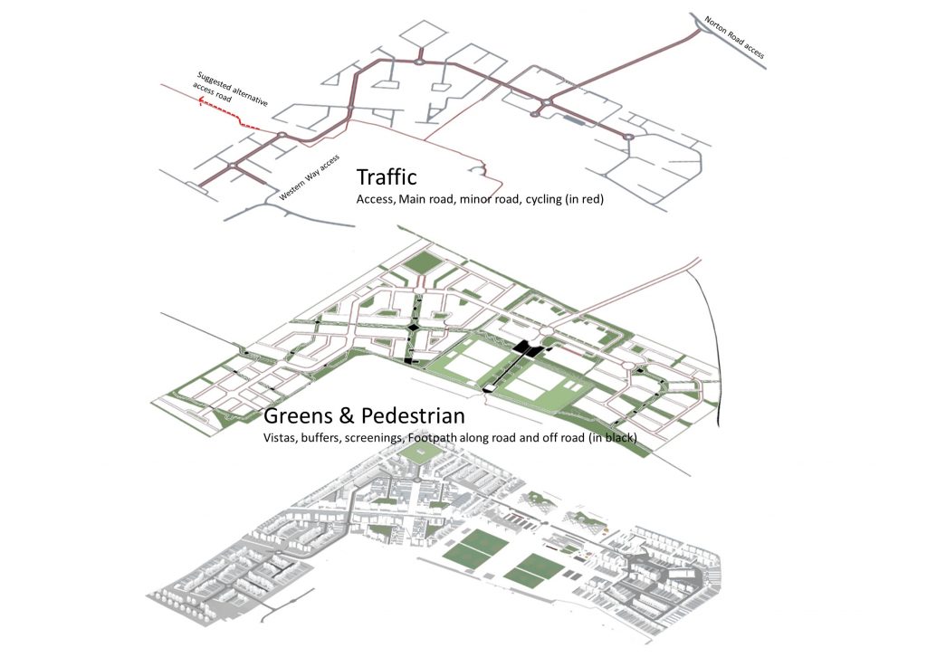
Greens/landscape
A promenade/avenue type of road running through the site from southwest to the east, serves as both traffic links and vistas, while a south-north running green corridor will form a cruciform landscaped zone with the existing green corridor associated power grid and future setbacks. New or existing footpath, cycling path, surface-run off drainage ditches and scattered children play-areas and other recreational functions will be woven into these landscaped green networks.
Down to the neighbourhood level (various pockets of smaller development), each will have its’ own inwards looking shared green area/open space, ultimately linked by footpath and inter-neighbourhood green buffers.
Traffic:
The spine of the development is its primary road that run through all the zones and is kept shortest possible. This promenade/avenue type of road serves as the primary traffic link that links to wider city road system on the north (Norton Road) and to the southwest (Grange estate), running from the southwest corner to the southeast corner, where it is downgraded into a loop/one-way secondary road. Subordinate to this level of road, there are a combination of small loops and cul-del-sac roads.
Roads are classified as:
- The main road (avenue characters), 7m two-way road maximum speed 30mph, tarmac surfacing, with 2m cycling track on each side, 2m plant reservation/trees, 3m footpath to the private boundaries. This avenue would engage half of the to-be-imported 2000 trees.
- Secondary roads: 5m road maximum speed 20mph tarmac surfacing, 2m plant/trees, 3m footpath to the private boundaries. Similar to the Western Way configuration.
- Neighbourhood roads: 5m road maximum speed 15mph tarmac surfacing, 2m footpath each side to the private boundaries. small loops with cul-del-sac roads
- Cycling path: 2m, either along the main road or integrated with the foot path within the green areas
- foot path: 1.5-2m, either along the roads or integrated or within the green areas
in addition, we hold reservation on weather the southwestern link to the Western Way would be welcomed by the mature Grange residential quarter. On that ground, we would suggest further relieve the traffic pressure from the Western Way by establishing a supplementary road link westerly, via the currently unmade road, to the Stotford Road roundabout.